Thursday 23 April
We set off for a tour of Guatemala, with a few relaxing days on the island of San Pedro in Belize to finish the trip. Guatemala is often called the Land of Eternal Spring thanks to its mild climate, and it’s famous for dramatic volcanic landscapes and a rich Mayan heritage. Slightly unexpectedly, it’s also the birthplace of the McDonald’s Happy Meal — created in the 1970s by a local businesswoman who wanted smaller, child‑friendly portions.
Having only visited Costa Rica in Central America before, I was excited to explore somewhere new. I suspected Guatemala would feel very different from its glossier neighbour.
The journey from London Heathrow to Guatemala City was a long one. We flew with United Airlines via Washington, and the first leg was surprisingly comfortable — the plane was quiet, and we ended up with a row of four seats between us for the eight‑hour flight. The landing was a bit bumpy, with the plane being buffeted around, but the touchdown itself was fine. At Dulles Airport we had to clear customs and collect our bags before re‑checking them for the Guatemala flight, but United had the process running smoothly and we had plenty of time.

The second flight was completely full, and by then the tiredness was setting in. As we approached Guatemala City, I spotted flashes of lightning in the distance and the runway looked freshly soaked from a downpour. We even felt a small skid as the wheels touched down.
At the airport we were met by our driver for the 1½‑hour journey to Antigua and our hotel, Las Marías. It was late by the time we arrived, so we headed straight to bed.
Friday 24 April
The Hotel Las Marías was a small, family‑run place built in a colonial style, with ten rooms arranged around a peaceful courtyard. Hidden behind a gated entrance alongside a few private homes, it sat in the shadow of the mighty Agua Volcano. This dormant giant dominates the Antigua skyline and is one of the most photographed landmarks in the city. Our room was tiny but charming, with a high pitched wooden ceiling. The walls, however, were paper‑thin — I’m convinced I could hear the neighbours breathing.


The next morning we set off for a tour of Antigua. Our group was a lively mix of Spanish, Chileans, a Colombian, Americans, and us. There were two guides: one for English speakers and one for Spanish. Our guide was Mina.
Antigua is a UNESCO World Heritage Site in the central highlands, known for its beautifully preserved Spanish colonial architecture and cobblestone streets. Founded in the 16th century, it served as Guatemala’s capital until the devastating earthquake of 1773 forced much of the population to relocate to what is now Guatemala City.


The town is surrounded by three volcanoes — Agua, Fuego, and Acatenango. Fuego is the active one, regularly sending plumes of ash into the sky. At 3,763m, it sits beside its sister volcano Acatenango, from which hikers can safely watch Fuego’s eruptions. It’s one of the most active volcanoes in the world.
We walked to The Plaza Central Park right in the centre and where locals and tourists meet up. It is surrounded by structures from Guatemala’s colonial past. At its centre a fountain, known as The Fountain of the Sirens.


At one of the square’s sides there are some neo classical arches under which there are 22 washing tanks from a time when people did communal laundry as their homes did not have washing facilities.


Antigua is also known for its Baroque churches, many of them left in ruins after the 1773 earthquake. One such church is San Augustine, built in 1657. The attached convent had a two-story arcade but these were destroyed along with the dome and main altar in the earthquake. It is still in ruins today and closed to the public along with numerous other churches in Antigua that have never been restored.

Our tour took us through several of the city’s most important buildings. We visited the Cathedral of San José, originally built in 1545 but repeatedly destroyed and rebuilt due to earthquakes. The 1773 quake left much of it in ruins, and only parts have been restored.


Adjacent to the main structure which is an active functioning church reconstructed in the 19th century from the old cathedral’s vestibule is the roofless ruins of the original cathedral. In the earthquake the main arches cracked and the dome collapsed into the nave permanently ending its use as Guatemala’s primary seat of Catholic power. I looked through the gate and was surprised to see there were still bits of intricate stucco plasterwork that had survived being exposed to the elements for several centuries.


Inside the church there was a lovely ornate golden Baroque-style altar. There was also The Shrine of the Buried Jesus which features a consecrated effigy of the crucified and buried Christ housed inside a golden wooden display case. Although it was beautifully ornate I found it a bit creepy and a a little too realistic, apparently real human hair, glass eyes and vivid resin blood was used. There was also a figure of ‘Our Lady of Help’ a version of the Virgin Mary and it is one of the oldest and most beloved Marian images brought here by early Spanish settlers. She wore a rather strange expression as though she really didnt want to be there!


We then visited San Francisco Church, home to the shrine of Santo Hermano Pedro — Central America’s first saint. Inside, the vaulted ceiling and central dome filled the space with soft natural light. The main wooden altar was decorated with ornate gold details and sculptures, including an 18th‑century portrait of the saint. The ceiling was draped in orange, yellow, and white fabric — colours symbolising both the Vatican and Mayan culture. The blending of Catholic and Mayan traditions is very visible in Guatemala, where many churches were built on top of former Mayan temples. Everywhere there were fresh flowers mainly yellow and orange roses and Bird of Paradise emanating a beautiful smell.


Next door, the convent ruins contain the Fuente de Pescados (Fish Fountain), a huge cross‑shaped fountain believed to be the largest colonial fountain in Central America.


We continued to the Palace of the Captains General, an 18th‑century Baroque complex on the central square. Completed in 1764, it served as the political and military headquarters for Central America. Its long two‑storey façade with high arches has survived numerous earthquakes.


We also visited the site of the old university, founded in 1676 — the oldest in Guatemala and the fourth established in the Americas. After the 1773 earthquake, it too was moved to Guatemala City. Today it houses the Museum of Colonial Art.


Antigua’s streets follow a neat grid pattern, running north–south and east–west around a central square. Most are cobbled, which must be tough on cars but does keep traffic slow. Because the streets are protected as historic monuments, repairs are done using traditional methods: stones set by hand into sand, without modern cement. We watched workers repairing a section — it looked incredibly labour‑intensive. The city also undergoes regular cleaning to remove volcanic ash that can damage the stones.


One of Antigua’s most famous hotel complexes incorporates the preserved ruins of the former Convent and Church of Santo Domingo, a vast Dominican monastery from the 16th and 17th centuries. The site now blends luxury hotel spaces with museums, gardens, restaurants, and archaeological remains.


We visited a jade museum, where we learned how highly the Mayans valued jade — more than gold. It symbolised life, fertility, power, and divinity. Jade comes in many colours beyond green: white, yellow, lavender (found only in Guatemala), black, and rare varieties like rainbow and galactic gold (also unique to Guatemala). We saw jade death masks; the wealthy were buried with jade to ensure a safe journey to the underworld, while even the poor were given a small piece, often placed in the mouth. Ancient carving was done using jade tools and could take years; today, diamond tools make the process far quicker.


We also discovered our Mayan day signs. Mine was Q’Anil (Seed) — symbolising creation, fertility, abundance, and the ripening of maize. It’s associated with the rabbit and the colour yellow, and people born under this sign are said to be intuitive, responsible, and creative.
Andy’s was Toj, the sign of gratitude and balance, linked to the sun and guarded by the shark. Those born under Toj are described as having strong spiritual light and fertile energy.
Nearly half of Guatemala’s population identifies as having direct Mayan heritage, though some estimates place it above 60%. There are more than 20 distinct Mayan ethnic groups, each with its own language and traditions. The largest include the K’iche’, Q’eqchi’, Kaqchikel, and Mam. Many others are Ladino — of mixed European and Indigenous ancestry.

After the museum, we wandered through a nearby market where Andy bought me lavender jade earrings and a jade infinity necklace. I’d admired the lavender jade version in the museum, but it was far too expensive — so mine is green jade instead.


Our final stops were two of Antigua’s most iconic landmarks. First, the Santa Catalina Arch, built in 1694, with its French clock added in the 1830s. It still has to be wound by hand every few days and was, impressively, showing the correct time. Then we visited La Merced, the Church of Mercy — arguably the most beautiful church in Antigua, with its vibrant yellow façade and intricate white stucco. It was built with exceptionally thick walls and reinforced buttresses to withstand earthquakes.


We stopped for a long lunch — a baguette and a couple of beers — then grabbed a coffee while asking for directions back. Antigua is full of lovely cafés, many with lush courtyards overflowing with plants. It’s an incredibly attractive town.


By late afternoon, the jet lag and the long walk had caught up with us. After a rest at the hotel, we ventured out again and found El Ilegal, an atmospheric bar covered in cool graffiti.
Saturday 25 April
We had a free day today and decided to walk into town. On the way, we stopped at the large San Lázaro Cemetery, not far from the hotel. Row after row of white mausoleums stretched out in perfect order, framed by tree‑lined pathways. There are around 3,000 mausoleums here, and the cemetery was established in 1834 on the site of a former leprosy hospital.


Walking into town wasn’t the easiest task — the pavements were narrow, high, and uneven. One wrong step and you could easily twist an ankle.
We retraced our route from the day before to find the artisan market. It took a bit of searching (and asking for directions), but we eventually found it. We bought some cushion covers and T‑shirts for the grandchildren.


Along the way we saw plenty of the famous “chicken buses”, known locally as camionetas. Locals often travel with livestock, hence the nickname. Many of the buses are retired US school buses, still bearing the names of the districts they once served. Others are far more flamboyant, decorated with bright murals, chrome, and flashing coloured lights.


We’d read about Caoba Farms Restaurant, known for its fresh farm‑to‑table food, so we headed there for lunch. It was a fair walk and the day was heating up, but we made it. A large group sat behind us, and one of them came over to explain that they were an English‑speaking social group who met a couple of times a week. Many were Americans who had moved to Guatemala. She kindly offered us a quick tour of the farm, showing us where they grew their vegetables and fruit. There were also some fascinating plants, including a rare jade vine with turquoise flowers.


In the evening we went to Posada de Don Rodrigo for dinner, accompanied by a marimba band and masked dancers. The main course was nice enough, but because we’d pre‑booked, our menu choices were limited — it felt a bit like a Groupon experience.


The marimba band, however, was excellent. I was fascinated by how several musicians played the same instrument at once, their mallets moving with perfect precision. The marimba, made of rosewood keys with resonators beneath, is Guatemala’s national instrument. Masked dancers and marimba music are inseparable parts of traditional festivals, so it was lovely to see them together. The dancers’ costumes were incredible, each wearing an elaborate carved wooden mask. Many represented animals, Mayan deities, and ancestral spirits.
Sunday 26 April
It was our 40th anniversary today — the reason we’d booked this holiday — and we were leaving Antigua to travel towards Lake Atitlán.
We set off along the Pan‑American Highway towards the famous Chichicastenango Market (“Chichi”), one of Central America’s largest and most vibrant Indigenous markets. It takes place every Thursday and Sunday in the Guatemalan highlands and draws people from all over the region.
As we drove, we saw groups of men on fast, powerful motorbikes racing along the highway as if it were a track. At least the road was in excellent condition. The route wound steeply through the mountains, full of sharp curves. This region is rich agricultural land thanks to the volcanic soil. Fields of maize, black beans, and avocados lined the hillsides, and onions are famously grown on the steep slopes around Lake Atitlán. We also passed plenty of fruit orchards.


From there, we continued on to Lake Atitlán. We stopped at a viewpoint where, for a few quetzales, you could step onto a colourful raised platform for photos. Behind us, the view stretched out across the lake and the surrounding volcanoes.


When we arrived in Chichicastenango, the market was already bustling. It’s an essential trading hub for the Indigenous K’iche’ Maya people. The stalls were a riot of colour, selling Maya textiles, handicrafts, wooden carvings, fruit, vegetables — and even live chickens.


Our guide took us to the Iglesia de Santo Tomás, right in the heart of the market. Built around 1545 on top of a former Mayan temple, it is still used by Maya priests today, who burn candles and incense as part of their rituals. Many candles were surrounded by rose petals; in Maya culture, flowers represent life force and act as “social agents” that embody supernatural beings. Petals are scattered as gestures of gratitude or requests for blessings.
The church’s 18 steps each represent one month of the Maya calendar. The steps are famously lined with women selling brilliant ceremonial flowers used as offerings.


We then visited the Chichicastenango Cemetery, often described as the most colourful cemetery in the world. The bright tomb colours each carry meaning: white for fathers (purity), turquoise for mothers (protection), yellow for grandparents, and others painted in the favourite colour of the deceased.
It was striking to see such a vibrant cemetery — incredibly photogenic, but also deeply symbolic. It’s a powerful example of sincretismo, the blending of Maya traditions with Roman Catholicism. Shamans often perform fire ceremonies and even chicken sacrifices here to communicate with the dead, though we didn’t witness any during our visit.


We left the town of Chichicastenango to take the next part of our journey to Panajachel on the banks of Lake Atitlán. It would take about 1 hour 20 minutes to get there back on the Pan American Highway.


Lake Atitlán is the deepest lake in Central America, reaching depths of 1,120 feet. It was formed by the massive “Los Chocoyos” super‑eruption around 84,000 years ago. Beneath its waters lies the sunken city of Samabaj, an ancient Mayan ceremonial site submerged around 250 AD, likely due to rising water levels or volcanic shifts.
We were staying at the Regis Hotel, close to the centre of Panajachel, with plenty of shops, cafés, and restaurants nearby.


We set out to find somewhere special for our anniversary dinner. First, we stopped for beers and nachos at an Uruguayan restaurant. Then we tried our guide’s recommendation, Atlantis, but it was completely empty and had a strange atmosphere, so we settled for just a cocktail.


Finally, we found Humaya, which also started out empty but looked lovely. We sat outside, ordered a bottle of wine and one of their speciality burgers, and thankfully the place soon filled up — giving it a much better atmosphere for our anniversary meal.


Monday 27 April
Today we were touring a couple of the villages around Lake Atitlán. At first we weren’t entirely sure our guide was coming — time kept ticking on and nobody appeared — but eventually another woman arrived for the tour, which reassured us we were at least in the right place. The guide finally turned up on his bike, and together we walked to another meeting point to collect the rest of the group. There were fifteen of us in total, a wonderfully international mix: American, Brazilian, Colombian, Trinidadian, Austrian, and of course us English.


A fast twenty‑minute boat ride took us to San Juan La Laguna. Our first stop was a honey centre, where we learned about Guatemalan beekeeping traditions. Honey production dates back to the Maya, who kept tiny stingless bees called Melipona. They produce a rare, highly prized medicinal honey that’s far more liquid than what we’re used to. We tasted three types of honey, including the Melipona variety, as well as a honey‑based mead.


If you look up from the shores of the lake the mountain ridge looks exactly like the profile of a sleeping Mayan face looking up to the sky. These peaks tower over San Juan La Laguna and are steeped in indigenous heritage.

Next, we learned about Mayan art. It is deeply symbolic, blending cosmology with everyday life — especially maize, the sacred crop of creation. It felt unusual at first that a crop could hold such significance, but maize is central to Maya belief: humanity was created from it.
The four colours of maize each carry meaning:
- White — the North; bones of humanity
- Yellow — the South; growth, abundance, fertility
- Red — the East; birth, beginnings, blood
- Black — the West; the underworld, rest, death
Green and blue are also important: green for jade, the most precious Maya material, and blue for life‑giving water. On the Bandera Maya, the four corners are red, black, white, and yellow, with green or blue at the centre.


We were shown paintings created from a bird’s‑eye perspective, where agricultural scenes are viewed from above — an unusual and striking artistic style.


From there, we visited a workshop where artisans create handwoven fabrics. We were shown each step of the process:
- Raw cotton bolls are deseeded by hand.
- The cotton is beaten with wooden sticks to fluff and align the fibres.
- Using a malacate (a handheld spindle), the fibres are twisted into thread — a difficult long‑draw technique requiring real skill.
- The yarn is soaked in natural mordants like banana stem or ash.
- Dyes come from local plants and insects, including cochineal for red.
- Finally, the weaver uses a backstrap loom, one end tied to a tree and the other around their waist, to create intricate symbolic designs.


The streets of San Juan La Laguna were incredibly colourful, filled with vibrant murals and overhead art installations. As we walked up the steep hill, a canopy of hundreds of coloured umbrellas hung above us. Another street had traditional handmade hats suspended overhead, and another featured hexagonal artworks floating above the walkway. It was a visual feast.


We stopped at a small local bar for a beer, grateful for the shade — it was another hot day.

San Juan La Laguna is internationally famous for its vibrant street murals that transform the village into an open-air art gallery. The murals are deeply tied to the town’s Tz’utujil Mayan identity, capturing the faces, customs, and daily struggles of the local community.


Lunch was in another lakeside village, Santiago Atitlán, where we had traditional tacos. We didn’t have much time to explore, but we did notice the distinctive men’s clothing: calf‑length pantalones with purple and white stripes.


Soon it was time to take the boat back to Panajachel. In the evening we went to Little Spoon, an atmospheric café with a terrace overlooking the town — the perfect relaxed end to a full day.


Tuesday 28 April
With a free morning we headed to the Atitlán Nature Reserve, a peaceful pocket of forest filled with butterflies, waterfalls and—much to my dismay—hanging bridges. They’re my absolute pet hate, so naturally the trail included several to cross. Character building, apparently.


The walk itself was lovely: shaded paths, the sound of water tumbling over rocks, and a surprise sighting of a Coati perched up a tree — a curious little creature related to raccoons, all long snout and ringed tail. A few birds flitted about, but with the heat already building they were keeping themselves sensibly scarce.


The butterfly dome was a highlight. It was alive with colour: shimmering Blue Morphos, clouds of Monarchs, elegant Pale‑spotted Swallowtails, and the striking Batwing Butterfly, whose wing shape really does resemble a tiny bat in flight. In the breeding lab we could see caterpillars and chrysalids at every stage, from tiny curled larvae to jewel‑like cocoons.
We walked out of the reserve and down to the lakeside with its beautiful views across to the mountains. Then it was a tuk tuk ride back to the hotel to get sorted out before we were back on the road.


Today we were bound for Guatemala City before flying on to Flores, while some of our group were heading home. The drive back took us along the Pan‑American Highway, winding through mountain roads and highland scenery. It’s only about 70 miles, but the twists and climbs stretch it into more than three hours.
Our hotel in Guatemala City was the sort of corporate place where you could be anywhere in the world. The shower, however, deserves a special mention — and not in a good way. The mechanism to divert the water to the shower head simply refused to cooperate, leaving me wrestling with a knob that had no intention of doing its job.
Wednesday 29 April
We were up at 4am for our flight to Flores — the kind of hour that feels like the middle of the night rather than the start of a day. Boarding was late, so it looked as though we’d be delayed, but the little prop plane was only half full and somehow we landed a couple of minutes early. The flight was smooth, quiet, almost serene.

From the airport we headed straight for Tikal. Roadworks brought us to a standstill for half an hour, the jungle steaming around us, but eventually the traffic began to inch forward and the rainforest opened into one of the most extraordinary archaeological sites in the world.


At the entrance, a scale model of the ancient city gives you your first hint of Tikal’s vastness — a stone metropolis swallowed by jungle, once home to tens of thousands of people.
As we started our walk around the complex we happen upon a clearing with wrecks of abandoned vehicles. These were likely to have been left from previous expeditions in the 1950s and 60s. The jungle conditions at Tikal were brutal on machinery, so once a vehicle suffered a major mechanical failure, it was often easier to abandon it than recover it through dense rainforest.

Tikal sits deep in the Petén rainforest of northern Guatemala, a UNESCO World Heritage Site since 1979. Between 200 and 850 A.D., it flourished as one of the most powerful Maya cities, filled with temples, palaces, plazas, and ceremonial complexes. Only about 20% of it is excavated today; the rest remains hidden beneath protective layers of earth and vegetation.


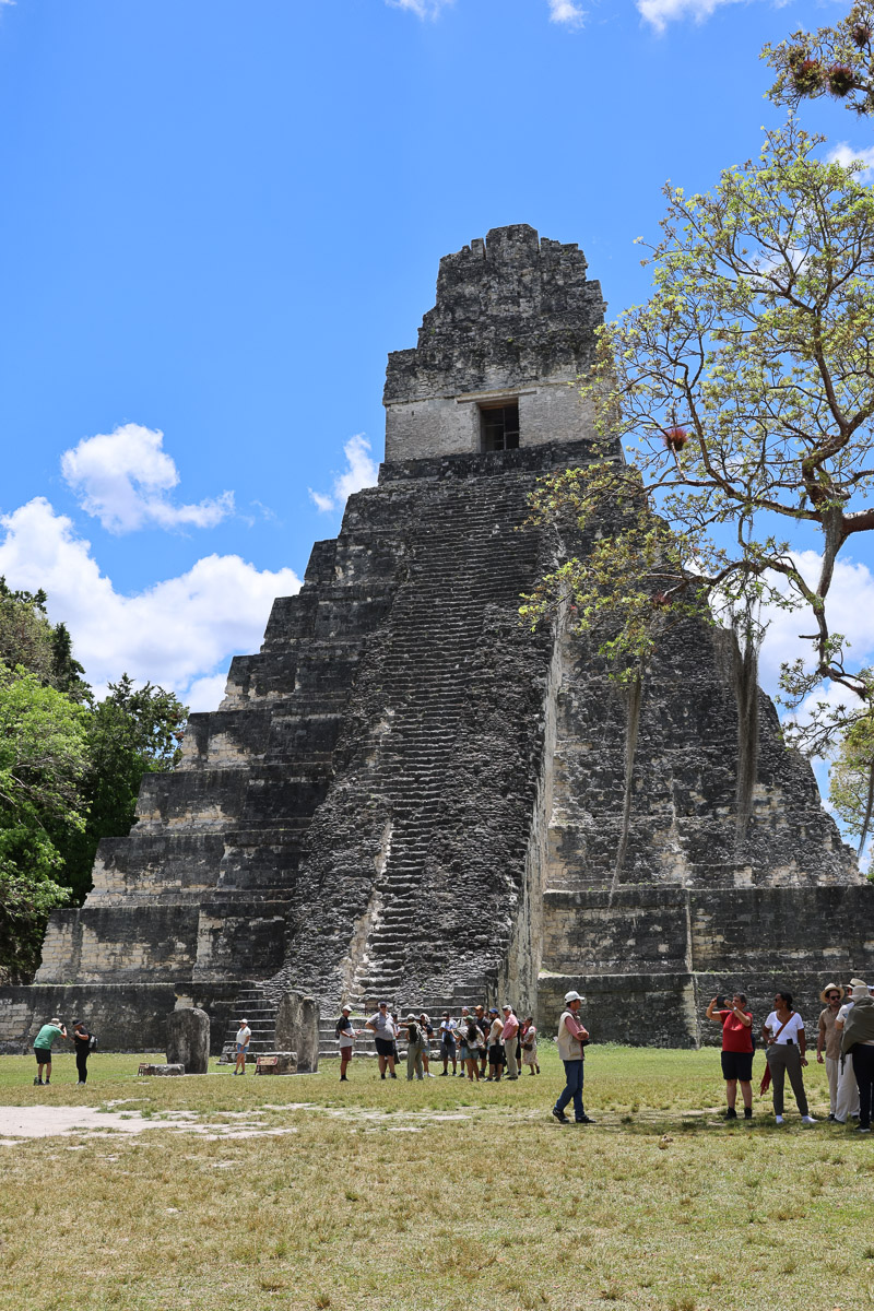
Temples I and II face each other across the Great Plaza like two stone giants locked in conversation.


- Temple I — The Great Jaguar
Tall, steep, and elegant, it was built as the tomb of a powerful king. - Temple II — The Masks
Broader and slightly shorter, it was constructed for his wife.


Their alignment was so precise that during rituals, the acoustics allowed a single voice to carry across the plaza — a deliberate design to amplify royal authority.
The most iconic structure is Temple IV, the one used as the Rebel lookout in Star Wars.
At 230 ft, it’s the tallest building in the complex and held the record for the tallest structure in the pre‑Columbian Americas for centuries.


From its summit, the tops of other temples rise like islands above a sea of green.
Temple IV access route is long, steep wooden staircase built up the north side of the pyramid. The Maya didn’t build steps on that face, so modern archaeologists added this route to protect the original stonework. Suddenly after a long climb you emerge at the top above the canopy. Here you can see the iconic Tikal skyline with Temple I and II piercing the jungle. I have to say it was worth the climb even though the temperature was nearly hitting 40!


Temple V is one of the most striking structures in the entire city, but it’s also one of the least understood. It sits slightly away from the Great Plaza, which is why many visitors stumble upon it almost by surprise — and then realise it’s absolutely enormous.


The North Acropolis is a vertical timeline of Maya civilisation.
For over 1,300 years, new temples were built directly on top of older ones to preserve the sacredness of the spot. Hidden beneath the visible stairs are masks of rain gods and monster deities — entire worlds sealed away.


The Mundo Perdido (Spanish for “Lost World”) was a massive complex was an astronomical instrument. During equinoxes and solstices, the sun rose in perfect alignment with smaller temples, acting as a giant calendar that guided planting seasons and ceremonial life.


The Central Acropolis (The Royal Maze) is a sprawling labyrinth of courtyards and chambers, this was the administrative and residential heart of Tikal’s elite.
Its design wasn’t just aesthetic — it was functional. The Maya engineered passive cooling, using narrow corridors to create a venturi effect that funnelled breezes through the palace. A natural air‑conditioning system, 1,500 years old.


The city was connected by wide, elevated limestone causeways called sacbes.
It also relied on sophisticated reservoirs and water purification systems — including zeolite, a mineral still used in modern filters.


Stela–altar pairs are one of the most beautifully symbolic and deeply ritual features of Tikal. They were often the centrepiece of major rituals. Tikal’s stelae are some of the most detailed in the Maya world. They typically show a ruler in elaborate headdress in ceremonial pose with details of dates and events.


Twin Pyramid Complex Q is one of the most important and best‑preserved ceremonial complexes at Tikal. It is one of several “twin‑pyramid complexes” at Tikal, an architectural form unique to the city and used only for major calendar rituals.


Recent LiDAR surveys have revealed over 60,000 hidden structures, suggesting the Maya lowlands may once have supported 10–15 million people.
The “gum trees” of Tikal are actually Sapodilla trees, the source of natural chicle.
It was chicleros — gum‑sappers searching for sap in the mid‑1800s — who rediscovered Tikal. Their machete scars are still visible on the bark.

We spotted White-nosed Coatis in the park a common sight at Tikal. These entertaining creatures are related to raccoons. .


Our hotel in Flores was Hotel Casona del Lago which was right on the Lake Peten Itza.

In the evening we took a tuk‑tuk to Flores Island. We found a bar overlooking the water and watched the sun melt into the lake — a quiet, golden end to a day spent walking through the bones of an ancient world.


Thursday 30 April
Today was our day to explore Yaxhá — pronounced Ya‑sha — the third‑largest Maya site in Guatemala and one of the most peaceful. Its name means “Blue‑Green Water,” a perfect description of the shimmering lake that hugs the edge of the ruins. A slight stomach upset meant that I was feeling a little bit under the weather and hoping that it wasn’t going to be quite as hot as the previous day.
Located in the northeastern Petén Basin, within the Yaxhá‑Nakum‑Naranjo National Park, the city flourished from around 600 BC to AD 900 as a major ceremonial centre and trading hub.
The first structure we saw was Structure 216; — Structure 216 is one of the few large pyramids at Yaxhá located in The North Acropolis. Andy climbed this one to get the views of Lake Yaxha. It rises over 100 feet and built in the classic stepped-pyramid style of the Maya.


There were more Maya stelae; the upright carved stone monuments we’d seen at Tikal. Each of the stones had a ruler, dates, scenes and events carved within them. here they were protected with thatched shelters as they were heavily eroded. The limestone quickly erodes in the jungle humidity.


Yaxhá has very few surviving stucco decorations and these would have once covered entire temple fronts, painted in bright reds, blues, and yellows. The picture below shows a rare surviving section.

There was another Maya stela that had survived better than the others and you could make out the carvings.

From here we found the Grupo Maler is major architectural complex.


Structure 218 is another major pyramid in the North Acropolis, located just beside Structure 216 to form the core of the North Acropolis ceremonial complex..


Compared to Tikal, Yaxhá feels gentler — fewer crowds, softer sounds, and a sense of stillness that settles over the plazas. The site contains around 500 structures, including:
- Temple pyramids — nine of them rising above the forest
- Ball courts — where ritual games were played with a heavy rubber ball
- A rare twin‑pyramid complex — one of the only examples outside Tikal
At its peak, Yaxhá stretched across 92 square miles and supported a population of more than 40,000 people.
In the ball courts, the Maya played a ceremonial game called pitz, using hips, thighs, and upper arms to keep the ball in motion. It was more than sport — it was politics, religion, and theatre woven together.

Yaxhá is a reminder that the Maya civilisation extended far beyond Guatemala. Their cities spread across southern Mexico, Belize, Honduras, and El Salvador, connected by trade, alliances, and rivalries.
They developed the most sophisticated hieroglyphic writing system in the pre‑Columbian Americas, along with advanced mathematics, astronomy, and architecture — achievements that still astonish archaeologists today.
It was another hot day, but thankfully the walking here was much flatter than Tikal.
High in the canopy we spotted spider monkeys, unmistakable with their long, loose limbs draped over the branches like sleepy acrobats. Still no toucans — they seem determined to remain mythical.

In the evening we took a tuk‑tuk back across to the Isle of Flores and found the Sky Bar — a perfect perch for watching the sun sink into the lake. Warm air, cold drinks, and the water turning gold. A gentle end to a gentler day.


Friday 1 May
The day began with a long drive — two hours through the landscapes of Petén toward the Belize border, then another two hours on the Belizean side to reach the ferry terminal. I’d hoped for more dramatic scenery, but the road threaded mostly through quiet stretches of countryside, the kind of journey where the miles blur into heat and dust.
The border crossing itself was surprisingly easy. First, an exit stamp from Guatemalan immigration, then a short walk across to Belizean immigration. Suddenly everything was in English — Belize is the only Central American country where English is the official language, though most people also speak Spanish or Kriol. It immediately made the process feel simpler, more familiar. And despite its small size, Belize still carries the imprint of the ancient Maya; some of the tallest structures in the country are still the old pyramids.
From the border, our Belizean driver took us straight to the ferry port in Belize City. The operation was impressively slick: bags tagged and taken to the hold, passengers funnelled aboard with practiced efficiency. The crossing to San Pedro took about an hour and a half, with a brief stop at Caye Caulker — a tiny island that looked as though it had been sketched from a postcard.

San Pedro greeted us with its trademark Caribbean energy. Known as La Isla Bonita, it’s famous for sandy streets, golf carts buzzing like oversized insects, and its closeness to the Belize Barrier Reef. Everything feels sun‑bleached and relaxed.
We couldn’t spot our guide at first, but eventually he materialised and whisked us to our hotel — Bananas on the Beach. The hotel itself was fine, a bit concrete, but the room was well equipped and the air‑conditioning was so powerful it bordered on arctic. In this heat, that felt like luxury.


We seemed to be a little way out of town, so we wandered further along the beach and found a bar — the kind of place where the sand is still warm underfoot and the sea breeze does half the work of cooling you down. A gentle end to a long travel day.
Saturday 2 May
San Pedro sits on Ambergris Caye, the largest island in Belize, and is often called La Isla Bonita — a nickname made famous by Madonna but embraced wholeheartedly by locals. The town has a distinctly Caribbean feel: colourful houses, reggae drifting from open windows, and a pace of life that seems to run on island time.
A few things that give San Pedro its character:
- Golf cart culture — the main way to get around; cars are rare, and no one seems to miss them.
- The Belize Barrier Reef — the second‑largest reef system in the world, just offshore, making the island a hub for snorkelling and diving.
- Sandy streets — many roads are still unpaved, giving the town a barefoot, beach‑town charm.
- Caribbean‑Mestizo culture — a blend of Belizean, Maya, Garifuna, and Creole influences that shape the food, music, and language.


San Pedro woke slowly this morning — the kind of place where the sun is already hot by breakfast and the breeze carries the smell of sea salt and sunscreen. We headed into town for brunch at Estel’s Dine by the Sea, a local favourite perched right on the sand. Estel’s is known for its Belizean breakfasts — fry jacks, Mayan eggs, and plates that arrive piled high and steaming. We went for fried eggs in a roll, simple but delicious, washed down with coffee and fresh orange juice while the Caribbean lapped quietly a few metres away.


May is the tail end of the busy season, and it showed. Our hotel felt almost empty — quiet corridors, unused loungers, the sense of having the place to ourselves. We claimed two chairs under a parasol on the beach and settled in for the afternoon, the sea shifting between turquoise and deep blue as the light changed.


In the evening we got something to eat at the nearby Mara Rocks, a bar just along the beach from our hotel.

Sunday May 3
Today was our big snorkelling day from San Pedro — the one everyone talks about when they mention Ambergris Caye. We started at Hol Chan Marine Reserve, one of the most famous protected areas in Belize. The boat stopped first at a floating pontoon where we signed in and were given wristbands before heading into the reserve itself.
Hol Chan means “Little Channel” in Mayan, a reference to the natural break in the reef that funnels marine life through the area. The water was beautifully clear, and for about 45 minutes we drifted over coral heads and schools of reef fish — Angelfish, Parrotfish, Snappers, and flashes of others I couldn’t name but admired all the same.


Our next stop was Shark Ray Alley, famous for its congregation of nurse sharks and stingrays. The sharks associate the boats with food, so as soon as we arrived they began circling, shadows sliding beneath the surface.


Snorkelling with sharks was a mental hurdle for me — I grew up on Jaws, a film that kept an entire generation out of the water for a summer. The guides fed the sharks on one side of the boat while we slipped into the water on the other. Even so, they were everywhere, brushing past us, bumping into our legs with surprising gentleness for such solid creatures.

Poor Andy got a mouthful of seawater as he entered and couldn’t film them, which was a shame, but the experience itself was unforgettable — surreal and exhilarating.

We climbed back aboard and headed to Coral Gardens, a calmer, shallower area with beautiful coral formations. Here we saw Loggerhead Turtles, one of which stopped feeding and surfaced right in front of me, its ancient face breaking the water for a breath.

There were more nurse sharks gliding below us and, most memorably, a Spotted Eagle Ray — elegant, patterned, and moving with the slow, effortless grace of a creature that knows it’s beautiful.

Our final snorkel stop was the North Channel, where manatees are sometimes seen drifting through the deeper water. Sadly, none appeared today. The current was strong, and we’d gone in without flippers, which made getting back to the boat a real effort. At one point I realised I was staring at the same rock beneath me despite kicking as hard as I could. Eventually, with a lot of determination, we made it back aboard.
Lunch was on Caye Caulker, the smaller, more laid‑back sister island to Ambergris Caye. Despite all the snorkelling, I wasn’t particularly hungry — the heat had taken the edge off my appetite. We wandered a little, but the midday sun was fierce, so we sensibly found a bar and had a cold beer instead.


In the afternoon we were back on the boat, stopping on the leeward side of Caye Caulker to feed Tarpons — huge, silver fish that launch themselves out of the water with startling force. We were given small fish to hold between thumb and forefinger, hand flat, and waited. When the tarpons leapt, the impact against your hand was a shock — powerful but harmless.

We then walked to a small beach where Southern Stingrays glided into the shallows. I couldn’t help thinking of Steve Irwin, but these rays were far more interested in the food the guides offered than in us.


Nearby was a tiny patch of mangrove where we searched for seahorses. They were incredibly hard to spot at first — tiny, curled, and camouflaged among the roots — but once you found one, your eyes adjusted and more began to appear, floating delicately in the shadows.

Finally, we boarded the boat for the 35‑minute ride back to San Pedro. By the time we reached the dock, the day’s exertions had caught up with us. We made the short walk to the bar at Mara Rocks once again — familiar, easy, and exactly what we needed after a day spent in the sun and sea. To be honest we were absolutely knackered!
